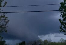
Residents of Spring Hill and Thompson’s Station were startled Thursday as a dark, ominous cloud swept across the sky during severe storms. Many feared a tornado was forming, but meteorologists quickly clarified that the feature, while alarming, was not a tornado. Instead, it was likely a wall cloud, a powerful storm feature that can sometimes precede tornadoes but does not always produce one.
Wall clouds form when warm, moist air inflow meets the cool, moist outflow from a storm’s downdraft. This interaction fuels a strong updraft, creating a lowered cloud formation beneath the thunderstorm’s rain-free base. Typically found in the southwest portion of a storm, wall clouds can range in size from less than a mile to nearly five miles in diameter. Some exhibit rapid upward motion and rotation, particularly when associated with a mesocyclone—a critical ingredient for tornado development.
The key difference between a wall cloud and a tornado lies in rotation and ground contact. While wall clouds may rotate, they do not always do so. A tornado, on the other hand, is a violently rotating column of air that must extend from the cloud base to the ground. In Wednesday’s storm, local meteorologists confirmed that while the wall cloud moved quickly, it lacked sustained rotation and did not touch down—disqualifying it as a tornado.
Wall clouds are a common sight in severe thunderstorms, and while they can signal an increased tornado risk, not all produce twisters.
We have reached out to the National Weather Service for further clarification on the storm and cloud formation but have not yet received a response.
Subscribe to our Newsletter!


